 |
| Click image to enlarge |
Saturday, October 19, 2013


Cricket season starts today
COMPETITION in the Southern Cricket Association is under way from today. It seems like just a few weeks ago that the last cricket season had finished, but here we are at the start of the 2013-14 season. All clubs from the Derwent Valley and Central Highlands have been busy preparing for what promises to be an excellent season of cricket.
The Molesworth club is the big mover in regard to new faces. There are all new office-bearers, including a new president in former player Craig Hay and a new coach in former Eagles premiership player David Adams. Adams' appointment has brought a list of new players to the club: brothers Jamie and Daniel Adams who played with Glenorchy in the TCA have joined the club while Nathan Hay from Claremont looks to be a good addition. These players and other shoulds account for their losses and one being the talented Ricky Martin who has transferred to Campania. Their is plenty of excitement around the Molesy boys and with all the hype, one would have to say they will be starting favourites in second grade.
New Norfolk has retained most of its players from last season and will again be coached by Adrian Eiszele. New Norfolk I finished third last season and will be looking to again be amongst the finals action for 2013-14. Rohan Heron has been appointed captain of New Norfolk I while Stephen Nichols again takes the reins of New Norfolk II. New players Nathan Cashion and Richard Graham will add to what is already a good list.
Bushy Park has done well in the last two seasons in fourth grade and have been put up to second grade. This is a big move for the Park boys, but I'm sure they will be leaving no stone unturned in challenging all comers. Bushy has retained all players from last season and has appointed Jason Crosswell and Troy "Wizard" Smith as joint captains. They also have some new office bearers and along with club stalwart Karen Fenton things should run pretty smoothly both on and off the field.
Gretna has retained all but a few players that have moved on, but on the gains they have youngsters Daniel Browning, Brodie Gleeson and Brock Nichols who have come through from the juniors. All three have showed great promise at training. Last season saw Gretna I make the finals for the first time since joining the SCA, finishing fourth. All players are very keen, including Owen Browning who is back after a few seasons coaching the clubs junior sides. Browning's experience will be very valuable, especially to the younger players.
The New Norfolk Cricket Club and Glenora District High School are again running Milo in2cricket for ages 5-10 years. New Norfolk has already started and is training on Thursdays and if you wish to join you can contact Leigh Berry on 0400 938 771. Glenora will start with a registration day at the school on Friday October 25 at 4.30pm and if you wish to sign up you can contact Annie McKenzie at the school on 6286 1301.
 |
| Molesworth Cricket Club president Craig Hay, senior coach David Adams and players Daniel Adams and Nathan Hay. |
 |
| New Norfolk Cricket Club coach Adrian Eiszele, junior development officer Leigh Berry and president Jamie Hill. |
Bushy Park has done well in the last two seasons in fourth grade and have been put up to second grade. This is a big move for the Park boys, but I'm sure they will be leaving no stone unturned in challenging all comers. Bushy has retained all players from last season and has appointed Jason Crosswell and Troy "Wizard" Smith as joint captains. They also have some new office bearers and along with club stalwart Karen Fenton things should run pretty smoothly both on and off the field.
 |
| Gretna Cricket Club young players Brodie Gleeson and Daniel Browning. |
Junior Cricket
JUNIOR cricket is again live and well with three clubs again fielding juniors teams this season. New Norfolk has Under 13s, while Molesworth and Gretna are both running Under 13s and Under 15s. The youth league season starts on Sunday, November 3, and all clubs are looking for more players. If you know of someone that is keen for cricket, contact your nearest club.The New Norfolk Cricket Club and Glenora District High School are again running Milo in2cricket for ages 5-10 years. New Norfolk has already started and is training on Thursdays and if you wish to join you can contact Leigh Berry on 0400 938 771. Glenora will start with a registration day at the school on Friday October 25 at 4.30pm and if you wish to sign up you can contact Annie McKenzie at the school on 6286 1301.
Story and photos by WADE GLEESON
Friday, October 18, 2013
Tonight's wind and water warnings
Australian Government Bureau of Meteorology Tasmania
RENEWED WARNING
MINOR FLOOD WARNING FOR LOWER RIVER DERWENT
Issued at 4:04pm on Friday 18 October 2013
by the Bureau of Meteorology, Hobart
Minor flooding continues in the lower reaches of the River Derwent below Meadowbank Dam and around Macquarie Plains.
Rainfall totals of up to 90mm were observed about the catchment to 9AM Thursday, with up to 20 mm observed to 9AM Friday. No further significant rainfall is expected during Friday and Saturday.
Most storages in the Derwent system are full with many dams currently spilling.
Derwent above Ouse River
High river flows continue in the upper reaches of the River Derwent and in the Dee and Nive Rivers, with most of the levels currently easing.
Ouse River
Renewed rises were observed during Thursday, with river levels easing.
Clyde River
Low level rises were observed overnight with levels to remain below their Minor flood levels.
Below Meadowbank Dam
Minor flooding continues below Meadowbank Dam with river level currently falling after peaking about 5.5m early Friday morning. The minor flood level is 4.1m.
Minor flooding continues about Macquarie Plains with river level currently steady about the Minor Flood Level (4.0 metres). Levels expected to fall below the minor flood level overnight Friday.
Tyenna River
Renewed rises were observed during Thursday, with river levels now easing.
Styx River
Renewed rises were observed during Thursday, with river levels now easing.
New Norfolk
High flows will continue around New Norfolk overnight Friday with river levels expected to remain below the Minor flood level.
Predicted River Heights/Flows: Based on observed rainfall, the following river peak heights are predicted:
FloodSafe advice is available at www.ses.tas.gov.au.
Road closure information is available at www.police.tas.gov.au
For emergency assistance call the SES on 13 25 00.
For life threatening situations, call 000 immediately.
Weather Forecast: Partly Cloudy.
Next Issue: By 10AM, Saturday, 19/10/2013.
Latest River Heights:
Location Height of River Date/Time of Observation
Derwent River below Lk St Clair 2.44m steady 11:05 PM THU 17/10/13
Ouse River at Ashton 1.25m steady 02:30 PM FRI 18/10/13
Clyde River at Bothwell 0.29m steady 03:00 PM FRI 18/10/13
Derwent River below Meadowbank Dam 5.22m steady 03:00 PM FRI 18/10/13
Derwent River at Macquarie Plains 4.03m steady 03:19 PM FRI 18/10/13
TYENNA RIVER AT NEWBURY 1.1m steady 01:00 PM FRI 18/10/13
STYX RIVER AT BRUCES BRIDGE 1.35m falling 03:24 PM FRI 18/10/13
Derwent River near Bryn Estyn 3.56m falling 01:00 PM FRI 18/10/13
DERWENT RIVER AT NEW NORFOLK 1.23m steady 03:23 PM FRI 18/10/13
For the latest rainfall and river level information see www.bom.gov.au/tas/flood/
for the period until midnight Saturday 19 October 2013.
Wind Warnings for Friday
Wind Warnings for Saturday
The next marine wind warning summary will be issued by 5am Saturday.
Check the latest Coastal Waters Forecast or Local Waters Forecast for information on wind, wave and weather conditions for these coastal zones.
RENEWED WARNING
MINOR FLOOD WARNING FOR LOWER RIVER DERWENT
Issued at 4:04pm on Friday 18 October 2013
by the Bureau of Meteorology, Hobart
Minor flooding continues in the lower reaches of the River Derwent below Meadowbank Dam and around Macquarie Plains.
Rainfall totals of up to 90mm were observed about the catchment to 9AM Thursday, with up to 20 mm observed to 9AM Friday. No further significant rainfall is expected during Friday and Saturday.
Most storages in the Derwent system are full with many dams currently spilling.
Derwent above Ouse River
High river flows continue in the upper reaches of the River Derwent and in the Dee and Nive Rivers, with most of the levels currently easing.
Ouse River
Renewed rises were observed during Thursday, with river levels easing.
Clyde River
Low level rises were observed overnight with levels to remain below their Minor flood levels.
Below Meadowbank Dam
Minor flooding continues below Meadowbank Dam with river level currently falling after peaking about 5.5m early Friday morning. The minor flood level is 4.1m.
Minor flooding continues about Macquarie Plains with river level currently steady about the Minor Flood Level (4.0 metres). Levels expected to fall below the minor flood level overnight Friday.
Tyenna River
Renewed rises were observed during Thursday, with river levels now easing.
Styx River
Renewed rises were observed during Thursday, with river levels now easing.
New Norfolk
High flows will continue around New Norfolk overnight Friday with river levels expected to remain below the Minor flood level.
Predicted River Heights/Flows: Based on observed rainfall, the following river peak heights are predicted:
- River Derwent at Macquarie Plains 4.0 - 4.1 metres (MINOR), late Friday afternoon 18/10/13.
- River Derwent at New Norfolk 1.7 - 1.9 metres (BELOW MINOR), Friday evening 18/10/13.
FloodSafe advice is available at www.ses.tas.gov.au.
Road closure information is available at www.police.tas.gov.au
For emergency assistance call the SES on 13 25 00.
For life threatening situations, call 000 immediately.
Weather Forecast: Partly Cloudy.
Next Issue: By 10AM, Saturday, 19/10/2013.
Latest River Heights:
Location Height of River Date/Time of Observation
Derwent River below Lk St Clair 2.44m steady 11:05 PM THU 17/10/13
Ouse River at Ashton 1.25m steady 02:30 PM FRI 18/10/13
Clyde River at Bothwell 0.29m steady 03:00 PM FRI 18/10/13
Derwent River below Meadowbank Dam 5.22m steady 03:00 PM FRI 18/10/13
Derwent River at Macquarie Plains 4.03m steady 03:19 PM FRI 18/10/13
TYENNA RIVER AT NEWBURY 1.1m steady 01:00 PM FRI 18/10/13
STYX RIVER AT BRUCES BRIDGE 1.35m falling 03:24 PM FRI 18/10/13
Derwent River near Bryn Estyn 3.56m falling 01:00 PM FRI 18/10/13
DERWENT RIVER AT NEW NORFOLK 1.23m steady 03:23 PM FRI 18/10/13
For the latest rainfall and river level information see www.bom.gov.au/tas/flood/
Updated Marine Wind Warning Summary for Tasmania
Issued at 4:07pm on Friday 18 October 2013for the period until midnight Saturday 19 October 2013.
Wind Warnings for Friday
- Strong wind warning for the following areas: Derwent Estuary, Frederick Henry and Norfolk Bay, Storm Bay, Channel, Far North West Coast, Banks Strait and Franklin Sound, East of Flinders Island, Upper East Coast and Lower East Coast
- Small craft alert for the following areas: Central Plateau Lakes and South West Lakes
Wind Warnings for Saturday
- Strong wind warning for the following areas: Derwent Estuary, Frederick Henry and Norfolk Bay, Channel, Upper East Coast, Lower East Coast and Central West Coast
- Small craft alert for the following areas: Central Plateau Lakes and South West Lakes
The next marine wind warning summary will be issued by 5am Saturday.
Check the latest Coastal Waters Forecast or Local Waters Forecast for information on wind, wave and weather conditions for these coastal zones.
Thursday, October 17, 2013
Dobson road open again
 |
| The tree that caused the trouble at Mt Field yesterday. |
The Parks and Wildlife Service reports on its Facebook page that a very large swamp gum situated about 45 metres from the road had pulled out of the ground, bringing several other large trees with it, and blocking the road.
The hole left by the root system measured about 12 metres across. A Department of Infrastructure, Energy and Resources crew and Parks and Wildlife staff worked to clear the road using a 14-tonne excavator.
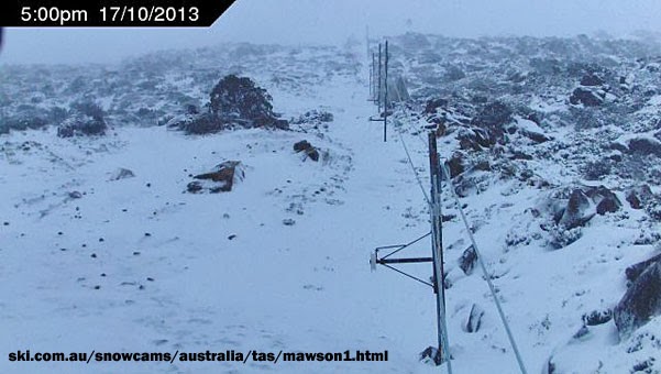 |
| The view from the top at 5pm today, courtesy of the Mt Mawson SnowCam. |
Wednesday, October 16, 2013
Lake Dobson Road closed
THE Lake Dobson Rd at Mt Field National Park has been closed due to multiple tree falls across the road in today's severe winds.
Staff from Parks and Wildlife and the Department of Infrastructure, Energy and Resources are working to clear the falls, and will update when the road is open.
Staff from Parks and Wildlife and the Department of Infrastructure, Energy and Resources are working to clear the falls, and will update when the road is open.
Severe weather warning updated
Severe Weather Warning for damaging winds
for people in the Upper Derwent Valley, Central North, North East, Western, Central Plateau, Midlands, East Coast and South East forecast districts
Issued at 12:14 pm EDT on Wednesday 16 October 2013.
Damaging winds expected to develop during today over much of Tasmania.
Weather Situation: An intense low pressure system will pass well to the southwest of Tasmania today with an associated cold front to cross the state from the west this evening.
Damaging winds around 50km/h with peak gusts of up to 120km/h are forecast for the East Coast district and 110km/h for the Western, Upper Derwent Valley and South East forecast districts and parts of the Central North, North East, Central Plateau and Midlands forecast districts.
Wind gusts of 133km/h have been recorded on Mt Wellington and 107km/h at Scotts Peak and Hartz Mountain in the past 6 hours.
The State Emergency Service and Tasmania Police advise that people should:
The next warning will be issued by 5pm Wednesday.
for people in the Upper Derwent Valley, Central North, North East, Western, Central Plateau, Midlands, East Coast and South East forecast districts
Issued at 12:14 pm EDT on Wednesday 16 October 2013.
Damaging winds expected to develop during today over much of Tasmania.
Weather Situation: An intense low pressure system will pass well to the southwest of Tasmania today with an associated cold front to cross the state from the west this evening.
Damaging winds around 50km/h with peak gusts of up to 120km/h are forecast for the East Coast district and 110km/h for the Western, Upper Derwent Valley and South East forecast districts and parts of the Central North, North East, Central Plateau and Midlands forecast districts.
Wind gusts of 133km/h have been recorded on Mt Wellington and 107km/h at Scotts Peak and Hartz Mountain in the past 6 hours.
The State Emergency Service and Tasmania Police advise that people should:
- Secure or put away loose items around your house, yard and balcony.
- Keep clear of fallen power lines.
- For emergency help in floods and storms, ring the SES on 13 25 00.
The next warning will be issued by 5pm Wednesday.
Wind and water warnings continue
THE Bureau of Meteorology has renewed the flood watch for the River Derwent Basin and issued warnings to bush walkers and sheep graziers.
Australian Government Bureau of Meteorology Tasmania
Note: This Flood Watch is a "heads up" for possible future flooding and is NOT a Flood Warning.
FLOOD WATCH FOR THE HUON AND RIVER DERWENT BASINS
Issued at 9:49am on Wednesday 16 October 2013
By the Bureau of Meteorology, Hobart
A Flood Watch Advice continues for the Huon River and the River Derwent.
In the 24 hours to 9AM Wednesday, rainfall totals up to 20mm have been observed across the Huon River basin, and up to 30mm in the River Derwent.
Further 20-50mm are possible in the same area from early Wednesday afternoon into Thursday, heavier in the western parts of the catchments.
River rises have been observed in the Huon river and the upper branches of the River Derwent this morning.
Forecast rain is expected to cause renewed stream and river rises during Wednesday with Minor flooding possible in some parts of the Huon and the Derwent rivers from late Wednesday onwards. Catchment specific warnings will be issued as required.
Strong and dangerous flows will be a hazard where river and stream levels are high over the remainder of the week.
FloodSafe advice is available at www.ses.tas.gov.au
Road closure information is available at www.police.tas.gov.au
For emergency assistance call the SES on 13 25 00.
For life threatening situations, call 000 immediately.
Weather Forecast: Areas of rain developing in the early Wednesday afternoon.
Next Issue: By 4PM, Wednesday, 16/10/2013
For the latest rainfall and river level information see www.bom.gov.au/tas/flood
Bush Walkers Weather Alert
for the Western and Central Plateau forecast districts
Issued at 12:48pm on Wednesday 16 October 2013.
Bush walkers are advised that snow as low as 600 metres is expected during Thursday in parts of the Western and Central Plateau forecast districts.
The next warning will be issued by 5pm Wednesday.
Warning to Sheep Graziers
for the Upper Derwent Valley, South East, King Island, North West Coast, Midlands, Central North, East Coast and North East forecast districts
Issued at 10:59am on Wednesday 16 October 2013.
Sheep Graziers are warned that cold temperatures, showers and strong westerly winds are expected during Wednesday night and early Thursday morning. Areas likely to be affected include the Upper Derwent Valley and South East forecast districts and parts of the East Coast, Midlands, Central North, North East, North West Coast and King Island forecast districts. There is a risk of losses of lambs and sheep exposed to these conditions.
The next warning will be issued by 5pm Wednesday.
Updated Marine Wind Warning Summary for Tasmania
Issued at 10:18am on Wednesday 16 October 2013
for the period until midnight Thursday 17 October 2013.
Wind Warnings for Wednesday
Wind Warnings for Thursday
The next marine wind warning summary will be issued by 4:05pm Wednesday.
Check the latest Coastal Waters Forecast or Local Waters Forecast for information on wind, wave and weather conditions for these coastal zones.
Australian Government Bureau of Meteorology Tasmania
Note: This Flood Watch is a "heads up" for possible future flooding and is NOT a Flood Warning.
FLOOD WATCH FOR THE HUON AND RIVER DERWENT BASINS
Issued at 9:49am on Wednesday 16 October 2013
By the Bureau of Meteorology, Hobart
A Flood Watch Advice continues for the Huon River and the River Derwent.
In the 24 hours to 9AM Wednesday, rainfall totals up to 20mm have been observed across the Huon River basin, and up to 30mm in the River Derwent.
Further 20-50mm are possible in the same area from early Wednesday afternoon into Thursday, heavier in the western parts of the catchments.
River rises have been observed in the Huon river and the upper branches of the River Derwent this morning.
Forecast rain is expected to cause renewed stream and river rises during Wednesday with Minor flooding possible in some parts of the Huon and the Derwent rivers from late Wednesday onwards. Catchment specific warnings will be issued as required.
Strong and dangerous flows will be a hazard where river and stream levels are high over the remainder of the week.
FloodSafe advice is available at www.ses.tas.gov.au
Road closure information is available at www.police.tas.gov.au
For emergency assistance call the SES on 13 25 00.
For life threatening situations, call 000 immediately.
Weather Forecast: Areas of rain developing in the early Wednesday afternoon.
Next Issue: By 4PM, Wednesday, 16/10/2013
For the latest rainfall and river level information see www.bom.gov.au/tas/flood
Bush Walkers Weather Alert
for the Western and Central Plateau forecast districts
Issued at 12:48pm on Wednesday 16 October 2013.
Bush walkers are advised that snow as low as 600 metres is expected during Thursday in parts of the Western and Central Plateau forecast districts.
The next warning will be issued by 5pm Wednesday.
Warning to Sheep Graziers
for the Upper Derwent Valley, South East, King Island, North West Coast, Midlands, Central North, East Coast and North East forecast districts
Issued at 10:59am on Wednesday 16 October 2013.
Sheep Graziers are warned that cold temperatures, showers and strong westerly winds are expected during Wednesday night and early Thursday morning. Areas likely to be affected include the Upper Derwent Valley and South East forecast districts and parts of the East Coast, Midlands, Central North, North East, North West Coast and King Island forecast districts. There is a risk of losses of lambs and sheep exposed to these conditions.
The next warning will be issued by 5pm Wednesday.
Updated Marine Wind Warning Summary for Tasmania
Issued at 10:18am on Wednesday 16 October 2013
for the period until midnight Thursday 17 October 2013.
Wind Warnings for Wednesday
- Strong wind warning for the following areas: Derwent Estuary, Frederick Henry and Norfolk Bay, Storm Bay, Channel, Central North Coast, Banks Strait and Franklin Sound, East of Flinders Island, Upper East Coast and Lower East Coast
- Small craft alert for the following areas: Central Plateau Lakes and South West Lakes
Wind Warnings for Thursday
- Strong wind warning for the following areas: Derwent Estuary, Frederick Henry and Norfolk Bay, Storm Bay, Channel, Upper East Coast and Lower East Coast
- Small craft alert for the following areas: Central Plateau Lakes and South West Lakes
The next marine wind warning summary will be issued by 4:05pm Wednesday.
Check the latest Coastal Waters Forecast or Local Waters Forecast for information on wind, wave and weather conditions for these coastal zones.
Subscribe to:
Posts (Atom)